
[ad_1]
The warnings come following a week of significant flooding due to heavy rain, with hundreds of homes and businesses in Cork, Waterford and Wexford suffering flood damage and further spot flooding seen in eastern counties today.
Met Éireann has issued a Status Orange rain warning for counties Kilkenny, Wexford, Waterford, valid until 1am on Tuesday.
Weather Explainer : What are weather status warnings
The three affected counties will see heavy and persistent rain and there is a possibility of thundery downpours.
A Status Yellow rain warning is in place for counties Carlow, Dublin, Kildare, Laois, Longford, Louth, Meath, Offaly, Westmeath, Wicklow, Roscommon. This warning is also valid until 1am on Tuesday.
Met Éireann meteorologist Rebecca Cantwell said where the rain is likely to be heaviest is “uncertain”.
“What we have at the moment is actually a really complex front associated with the low pressure system that’s moving over us, so it’s actually quite an unstable front,” she said.
“We’re likely to see heavy downpours associated with that. It’s moving north-eastwards but the track is still very uncertain. It’s going to stall at some stage because it’s a waving front but where it’s going to stall exactly, the models are moving it around,” she said.
Tonight, lingering heavy rain across the north and east will clear early on with clear spells and scattered heavy showers following.
Patches of mist and fog are possible too.
Lowest temperatures of 5 to 8 degrees with just light easterly or variable breezes.
While on Tuesday, any mist and fog will clear in the morning.
A mix of cloud and scattered showers will occur for the rest of the day, some heavy, but some dry spells at times too.
Highest temperatures of 11 to 14 degrees in near clam conditions.
Unfortunately there isn’t a break in the poor weather on the horizon with Met Éireann predicting further showers during the week and more heavy rain on Thursday and Friday.
In Co Kilkenny, with an Orange Status rain warning in place, children had to be carried from school this afternoon after the entire entrance to the premises was flooded.
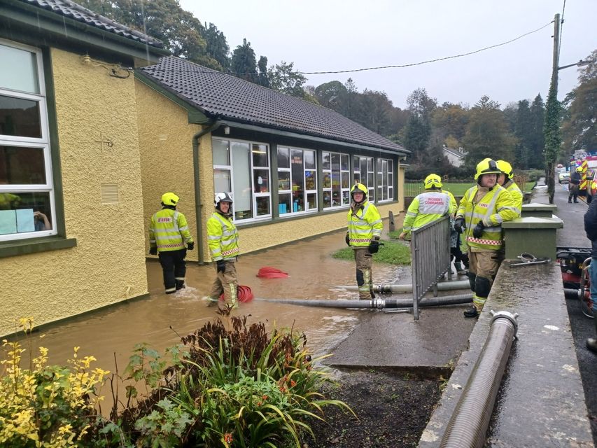
Kilkenny fire fighters assisting at Inistioge NS on Monday afternoon.
Meanhwhile, Cork County Council is bracing for further flooding following the destruction caused by Storm Babet last week. There will be up to 30mm of rain.
The council said east Cork is the area “of greatest concern” based on current forecasts.
Leo Varadkar: Financial support to be given for homes and firms destroyed by Babet
“Residents in flood-prone areas who have previously been issued with sandbags are advised to take all necessary precautions considering the forecast,” Cork County Council said in a statement.
“Property owners across the county are advised to take all necessary precautions to safeguard their property. In the event of river levels rising to a level of concern, the council will endeavour to advise residents in areas that may be at greatest risk.”
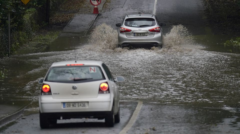
A car is driven through a flooded road in Faithlegg, Co. Waterford, Ireland (Niall Carson/PA)
Met Éireann forecaster Michelle Dillon told RTÉ Radio One’s Drivetime the heaviest rainfall is down in Wexford. There are also some heavy rains in Roscommon.
“We’ve Yellow rainfall warnings for many counties, but for the western southwest, they’re going to expire now,” she said.
“From 6pm this evening, we’re looking at rainfall warnings in operation for Leinster, Roscommon and also for Waterford.
“The heaviest of the rain is going to continue to move away to the east and northeast.”
There are some thunderstorms on the southeast coast, which caused the flooding and orange level category rainfall warning, Ms Dillon explained.
However, she described it as an “improving situation”.
There will be some heavy thundery bursts of rain, bringing the risk of flooding in Wexford, Leinster, Waterford, and Roscommon.
“The heaviest of the rain hasn’t reached Dublin yet. So that’s going to continue to track east and north-eastwards,” she added.
Met Éireann has advised to reduce the speed on the road as the poor visibility will continue along with the chance of flooding on the roads. The forecaster has also advised on a much better day tomorrow.
“Probably there might be a hint of yellow somewhere, but unlikely to reach rainfall warning,” she added.
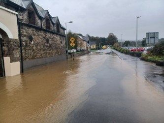
Flooding in Inistioge, Co Kilkenny.
Niall Healy, director of services with responsibility for roads and transportation at Cork County Council, told the programme the local authority had “little opportunity” to be fully prepared for the “intensity of rainfall that fell” last week.
In reference to Mr Murphy’s explanation, he said the system in place is hugely beneficial and the council are hugely appreciative of it.
“A more localised system of warning for Cork county would be of huge assistance to us because in effect we experienced very different circumstances across Cork county last week,” he said.
Mr Healy noted that west Cork escaped “relatively lightly” while north Cork experienced an intensity of rainfall that far exceeded both eastern and western parts of the county that same night.
“There is an opportunity for improvement there,” Mr Healy noted.
[ad_2]
Source link
